 by
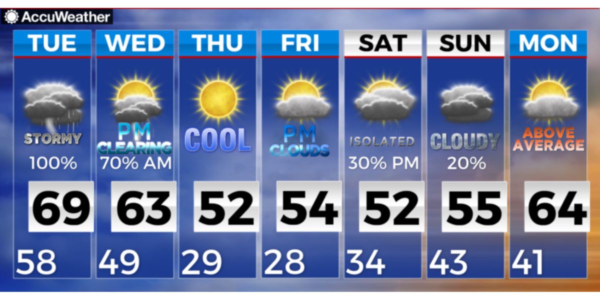
by Springfield, MA – The weather this weekend in Western Massachusetts is shaping up to be cold and windy, with some snow expected Sunday night.
Saturday Weather Update:
It’s going to be a chilly start to Saturday, with temperatures in the 20s to 30s in the morning across Western Massachusetts. There was some rain last night, and in some spots, there may be slick patches of black ice early in the morning. As the day progresses, cloud cover will start to break up, but it’s going to stay breezy. Winds will be strong, coming from the northwest at 10-20 mph, with gusts up to 30 mph.
Due to the wind, it will feel much colder than the actual temperature. In fact, with the wind chill, temperatures will feel like they are in the single digits or lower teens in the valley. In the hills, expect feels-like temperatures near or below zero. So, it’s definitely going to be a cold and blustery day!
By the evening, skies will clear up a bit, but it will stay very cold. Overnight temperatures will drop to single digits, and in some areas, they could even get close to zero. With the winds continuing, the “feels like” temperatures will be below zero for most of the region.
Sunday Forecast:
Sunday will start out dry and cold, with temperatures below freezing in the morning. Expect some sunshine early, but clouds will start to build up in the afternoon. As the evening approaches, the weather will start to change. Between 7:00 pm and 9:00 pm, a low-pressure system will bring light snow to the region.
The snow won’t last long, but it will affect the area during the overnight hours, likely tapering off between 3:00 am and 5:00 am on Monday. This is expected to be a quick-moving and weak system, so it won’t cause major problems, but there will be some snow accumulation.
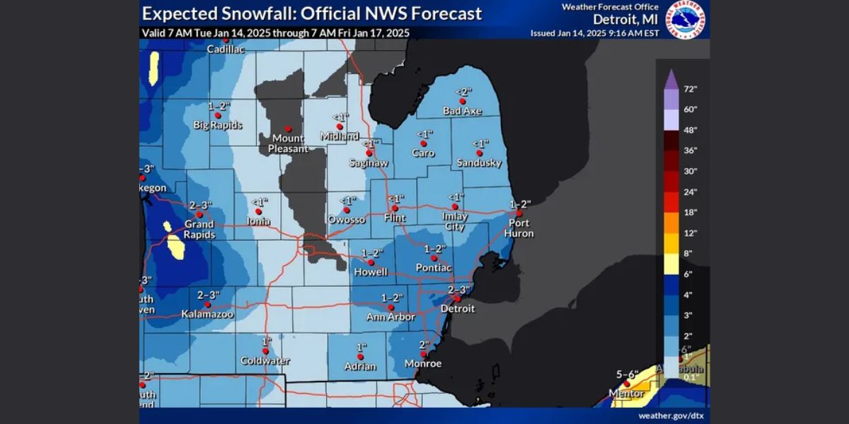
Snow Accumulation and Impact:
In the lower Pioneer Valley, we’re expecting around 1 to 3 inches of snow. Further north and west, you might see a bit more snow, with totals reaching 2 to 4 inches. In some isolated spots, it could be as much as 5 or 6 inches. However, since the snow will fall mostly at night and not during the morning commute, the impact will be minimal.
No First Alert Weather Days will be issued for this snow because the amount of snow expected is minor, and the timing shouldn’t cause major travel delays.
Monday Weather:
After a cold start on Sunday night, Monday will bring much milder conditions. Expect temperatures to warm up into the 40s by the afternoon. A southerly breeze will help bring in warmer air, but it’s not going to stay warm for long. Temperatures will fall back closer to normal later in the week.
Looking Ahead to Thursday:
Looking ahead, we could see another round of wintry weather on Thursday. Some weather models are suggesting a mix of snow and rain, but we’ll know more about the exact timing and details as the week goes on.
(Source : westernmassnews.com)